
Gambar:Day Pass down the Red Sea.ogv
Ukuran ieu pramidang JPG ti ieu berkas OGG: 800 × 531 pixel Resolusi lianna: 320 × 213 pixel | 640 × 425 pixel | 840 × 558 pixel.
Berkas asli (Koropak vidéo Theora ogg, lilana 16 d, 840×558 piksel, 2,04 Mbps)
| Berkas ieu asalna ti Wikimedia Commons. Kaca ngeunaan katerangan berkas ieu di Commons aya disalin di handap. Commons téh hiji gudang berkas bébas nu eusina disumbang ku balaréa. |
Ringkesna
| Pedaran |
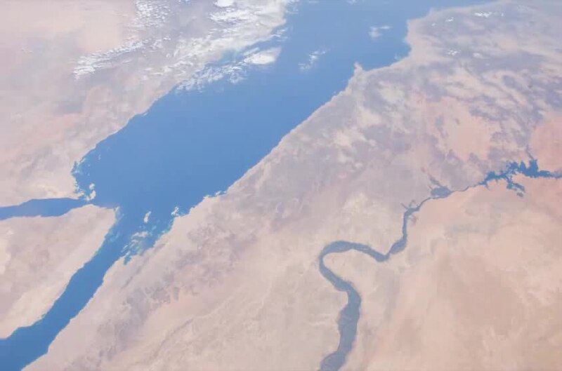
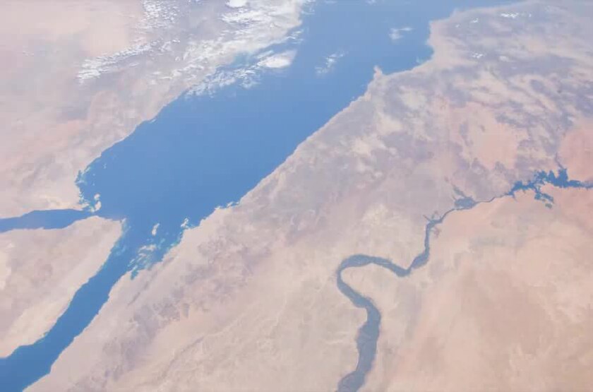
English: This video over the south-eastern Mediterranean Sea and down the coastline of the Red Sea was taken by the crew of Expedition 29 on board the International Space Station. This sequence of shots was taken September 17, 2011 from 12:14:25 to 12:24:55 GMT, on a descending pass from southern Greece to the Horn of Africa. The Nile River Delta that drains into the Mediterranean Sea can be seen well near the beginning of the video. As the ISS continues on its descending track south-east down the Red Sea, a thunderstorm can be seen just north of Djibouti. |
| Titimangsa | |
| Sumber | The Gateway to Astronaut Photography of Earth |
| Pangarang | ISS Expedition 29 crew |
Lisénsi
| Berkas ini berada dalam domain publik di Amerika Serikat karena semata-mata diciptakan oleh NASA. Kebijakan hak cipta NASA menyatakan bahwa "materi NASA tidak dilindungi oleh hak cipta kecuali dicatat". (Lihat Template:PD-USGov, Halaman kebijakan hak cipta NASA atau JPL Image Use Policy.) | ||
 |
Peringatan:
|
Jujutan berkas
Klik dina titimangsa pikeun nempo koropak nu aya dina mangsa éta.
| Titimangsa | Miniatur | Ukuran | Pamaké | Kamandang | |
|---|---|---|---|---|---|
| kiwari | 24 Oktober 2011 13.10 | 16 d, 840 × 558 (3,79 MB) | Originalwana | {{Information |Description ={{en|1=This video over the south-eastern Mediterranean Sea and down the coastline of the Red Sea was taken by the crew of Expedition 29 on board the International Space Station. This s |
Pamakéan berkas
Ieu berkas dipaké ku kaca di handap:
Pamakéan berkas sajagat
Wiki lianna anu maké ieu berkas:
- Pamakéan di ar.wikipedia.org
- Pamakéan di ban.wikipedia.org
- Pamakéan di bn.wikipedia.org
- Pamakéan di ceb.wikipedia.org
- Pamakéan di en.wikipedia.org
- Pamakéan di hak.wikipedia.org
- Pamakéan di hif.wikipedia.org
- Pamakéan di id.wikipedia.org
- Pamakéan di ig.wikipedia.org
- Pamakéan di ilo.wikipedia.org
- Pamakéan di mai.wikipedia.org
- Pamakéan di ms.wikipedia.org
- Pamakéan di ne.wikipedia.org
- Pamakéan di pa.wikipedia.org
- Pamakéan di ps.wikipedia.org
- Pamakéan di sl.wikipedia.org
- Pamakéan di te.wikipedia.org
- Pamakéan di zh-min-nan.wikipedia.org
- Pamakéan di zh-yue.wikipedia.org