
Gambar:Kansai closeup.jpg
Euweuh résolusi nu leuwih luhur.
Kansai_closeup.jpg (800 × 600 piksel, ukuran koropak: 66 KB, tipeu MIME: image/jpeg)
| Berkas ieu asalna ti Wikimedia Commons. Kaca ngeunaan katerangan berkas ieu di Commons aya disalin di handap. Commons téh hiji gudang berkas bébas nu eusina disumbang ku balaréa. |
Ringkesna
| Pedaran |
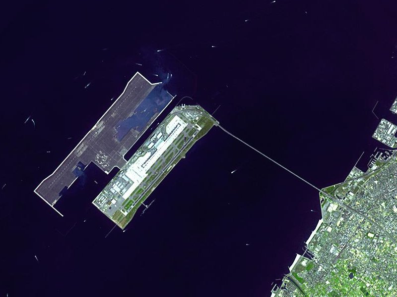
Satellite image of Kansai International Airport in Osaka Bay in Japan. This is a closeup - for an overview image showing the airport on its artificial island in the bay, see Image:Wfm kansai overview.jpg |
| Titimangsa | |
| Sumber |
Taken from an uncopyrighted image NASA Earth Observatory |
| Pangarang | NASA Earth Observatory |
| Widi (Migunakeun deui ieu berkas) |
"The purpose of NASA's Earth Observatory is to provide a freely-accessible publication on the Internet where the public can obtain new satellite imagery and scientific information about our home planet. The focus is on Earth's climate and environmental change. In particular, we hope our site is useful to public media and educators. Any and all materials published on the Earth Observatory are freely available for re-publication or re-use, except where copyright is indicated. We ask that NASA's Earth Observatory be given credit for its original materials." |
| Versi lainnya |

| Lokasi objek | | Lihat gambar ini dan gambar di sekitarnya di: OpenStreetMap |
|---|
Lisénsi
| Berkas ini berada dalam domain publik di Amerika Serikat karena semata-mata diciptakan oleh NASA. Kebijakan hak cipta NASA menyatakan bahwa "materi NASA tidak dilindungi oleh hak cipta kecuali dicatat". (Lihat Template:PD-USGov, Halaman kebijakan hak cipta NASA atau JPL Image Use Policy.) | ||
 |
Peringatan:
|
en.Wikipedia upload log
The en.Wikipedia description page is/was here. All following user names refer to en.Wikipedia.
- 2004-04-05 19:30 Finlay McWalter 800×600 (66 KB) (nasa image of kansai airport)
Jujutan berkas
Klik dina titimangsa pikeun nempo koropak nu aya dina mangsa éta.
| Titimangsa | Miniatur | Ukuran | Pamaké | Kamandang | |
|---|---|---|---|---|---|
| kiwari | 13 Désémber 2005 03.46 | | 800 × 600 (66 KB) | Sam916~commonswiki | Satellite image of Kansai International Airport in Osaka Bay in Japan. This is a closeup - for an overview image showing the airport on its artificial island in the bay, see Image:Wfm kansai overview.jpg Taken from an uncopyrighted imag |
Pamakéan berkas
Euweuh kaca anu maké ieu berkas.
Pamakéan berkas sajagat
Wiki lianna anu maké ieu berkas:
- Pamakéan di ar.wikipedia.org
- Pamakéan di ast.wikipedia.org
- Pamakéan di bbc.wikipedia.org
- Pamakéan di bg.wikipedia.org
- Pamakéan di bh.wikipedia.org
- Pamakéan di bn.wikipedia.org
- Pamakéan di de.wikipedia.org
- Pamakéan di el.wikipedia.org
- Pamakéan di en.wikipedia.org
- Pamakéan di en.wikibooks.org
- Pamakéan di es.wikipedia.org
- Pamakéan di eu.wikipedia.org
- Pamakéan di fa.wikipedia.org
- Pamakéan di fi.wikipedia.org
- Pamakéan di he.wikipedia.org
- Pamakéan di hu.wikipedia.org
- Pamakéan di id.wikipedia.org
- Pamakéan di io.wikipedia.org
- Pamakéan di it.wikipedia.org
- Pamakéan di it.wikivoyage.org
- Pamakéan di ja.wikipedia.org
- Pamakéan di ko.wikipedia.org
- Pamakéan di lfn.wikipedia.org
- Pamakéan di ml.wikipedia.org
- Pamakéan di mn.wikipedia.org
- Pamakéan di ms.wikipedia.org
- Pamakéan di nl.wikipedia.org
- Pamakéan di pt.wikipedia.org
- Pamakéan di ro.wikipedia.org
- Pamakéan di simple.wikipedia.org
- Pamakéan di sl.wikipedia.org
- Pamakéan di sr.wikipedia.org
- Pamakéan di sv.wikipedia.org
- Pamakéan di ta.wikipedia.org
- Pamakéan di uk.wikipedia.org
- Pamakéan di vi.wikipedia.org
- Pamakéan di www.wikidata.org
- Pamakéan di zh-yue.wikipedia.org
- Pamakéan di zh.wikipedia.org
Témbongkeun pamakéan global leuwih loba pikeun ieu berkas.