
Gambar:Solomon Islands 1989.jpg
Ukuran ieu pramidang: 750 × 600 pixel. Resolusi lianna: 300 × 240 pixel | 600 × 480 pixel | 961 × 768 pixel | 1.203 × 962 pixel.
Berkas asli (1.203 × 962 piksel, ukuran koropak: 131 KB, tipeu MIME: image/jpeg)
| Berkas ieu asalna ti Wikimedia Commons. Kaca ngeunaan katerangan berkas ieu di Commons aya disalin di handap. Commons téh hiji gudang berkas bébas nu eusina disumbang ku balaréa. |
Ringkesna
| Pedaran |
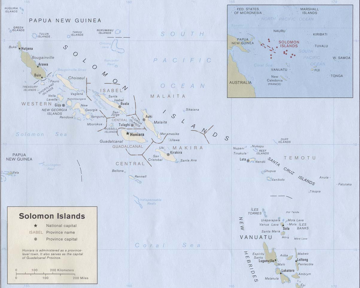
English: Map of the Solomon Islands as of 1989. Province names are included, except for two new provinces as of 1995: the Rennell and Bellona Province (formerly part of Central Province) and the Choiseul Province (formerly part of Western Province). |
| Titimangsa | |
| Sumber | Solomon Islands (Political) 1989 from Perry-Castañeda Library Map Collection: Solomon Islands Maps. Cropped to remove white space from edges of map. |
| Pangarang | U.S. Central Intelligence Agency |
| Widi (Migunakeun deui ieu berkas) |
Public domain |
Lisénsi
| This image is a work of a Central Intelligence Agency employee, taken or made as part of that person's official duties. As a Work of the United States Government, this image or media is in the public domain in the United States.
|

|
Jujutan berkas
Klik dina titimangsa pikeun nempo koropak nu aya dina mangsa éta.
| Titimangsa | Miniatur | Ukuran | Pamaké | Kamandang | |
|---|---|---|---|---|---|
| kiwari | 25 Agustus 2009 19.27 | | 1.203 × 962 (131 KB) | Zyxw | == {{int:filedesc}} == {{Information | description = {{en|Map of the Solomon Islands as of 1989. Province names are included, except for two new provinces as of 1995: the [[:en:Rennell and B |
Pamakéan berkas
Ieu berkas dipaké ku kaca di handap:
Pamakéan berkas sajagat
Wiki lianna anu maké ieu berkas:
- Pamakéan di af.wikipedia.org
- Pamakéan di ar.wikipedia.org
- Pamakéan di az.wiktionary.org
- Pamakéan di bg.wikipedia.org
- Pamakéan di br.wikipedia.org
- Pamakéan di ca.wikipedia.org
- Pamakéan di cs.wikipedia.org
- Pamakéan di en.wikipedia.org
- Pamakéan di es.wikipedia.org
- Pamakéan di eu.wikipedia.org
- Pamakéan di fr.wikipedia.org
- Pamakéan di gl.wikipedia.org
- Pamakéan di hr.wikipedia.org
- Pamakéan di hu.wikipedia.org
- Pamakéan di hy.wikipedia.org
- Pamakéan di id.wikipedia.org
- Pamakéan di pa.wikipedia.org
- Pamakéan di pl.wikipedia.org
- Pamakéan di pl.wiktionary.org
- Pamakéan di pt.wikipedia.org
- Pamakéan di ro.wikipedia.org
- Pamakéan di ru.wikipedia.org
- Pamakéan di sco.wikipedia.org
- Pamakéan di simple.wikipedia.org
- Pamakéan di tpi.wikipedia.org
- Pamakéan di tr.wikipedia.org
- Pamakéan di uk.wikipedia.org
- Pamakéan di wuu.wikipedia.org
Témbongkeun pamakéan global leuwih loba pikeun ieu berkas.