Gunung Agung: Béda antarrépisi
SieBot (obrolan | kontribusi) m bot Nambih: ms:Gunung Agung |
mTidak ada ringkasan suntingan |
||
| Baris ka-13: | Baris ka-13: | ||
}} |
}} |
||
'''Gunung Agung''' nyaeta salasahiji gunung di [[Bali]], [[Indonésia]]. Dina 3,142 m saluhureun laut, [[stratovolcano]] ieu mangrupakeun gunung pangluhurna di Pulo Bali. Gunung ieu aya di [[Kacamatan]] [[Rendang, Karangasem|Rendang]], [[Kabupatén]] [[Kabupatén Karangasem|Karangasem]], [[Propinsi]] Bali. |
'''Gunung Agung''' nyaeta salasahiji gunung di [[Bali]], [[Indonésia]]. Dina 3,142 m saluhureun laut, [[stratovolcano]] ieu mangrupakeun gunung pangluhurna di Pulo Bali. Gunung ieu aya di [[Kacamatan]] [[Rendang, Karangasem|Rendang]], [[Kabupatén]] [[Kabupatén Karangasem|Karangasem]], [[Propinsi]] Bali. |
||
| ⚫ | |||
Gunung Agung is still active, with a large and very deep crater which occasionally belches smoke and ash. From a distance, the mountain appears to be perfectly conical, despite the existence of the large crater. |
|||
Gunung Agung aktip keneh, kalayan kawah nu lega jeung jero nu kadang-kadang ngaluarkeun [[haseup]][ jeung [[lebu]]. Ti kajauhan, gunung ieu katingali nyongcot sampurna, sok sanajan aya kawah nu lega oge. |
|||
From the peak of the mountain, it is possible to see the peak of [[Gunung Rinjani]] on the island of Lombok, although both mountains are frequently covered in cloud. The best time to climb the mountain is at dawn when the air is still clear, giving spectacular views. |
|||
Ti punclut gunung, urang bisa nempo punclut [[Gunung Rinjani]] di pulo [[Lombok]], sanajan duanana sering kasimbutan ku halimun oge. Wanci nu pangalusna keur naek ka gunung ieu nyaeta nalika fajar mangsa udarana beresih keneh, loba tetempoan nu bisa katingali kalayan hade. |
|||
| ⚫ | |||
==Naék gunung== |
==Naék gunung== |
||
Aya tilu jalan utama nu deukeut tur ilahar dipake keur naek ka gunung ieu. Ti kidul, wetan kidul, jeung ti kulon. The western approach is the most commonly taken path, as it leads from the Temple of Besakih. It also has spectacular views along the length of the trail. It is important that hikers take their own water with them as the only source of water on the trail is a well that is considered holy and therefore forbidden. Much of the climb is loose soil and rock, so climbers are encouraged to use adequate footwear. |
|||
==Bitu taun 1963-64== |
==Bitu taun 1963-64== |
||
| Baris ka-29: | Baris ka-29: | ||
== Tempo oge == |
== Tempo oge == |
||
* [[Daptar gunung |
* [[Daptar gunung seuneuan di Indonésia]] |
||
== Tumbu luar == |
== Tumbu luar == |
||
Révisi nurutkeun 26 Oktober 2007 02.59
| Gunung Agung | |
|---|---|
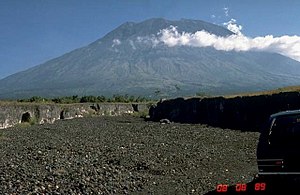
 Gunung Agung taun 1989 | |
| Luhur | 3,031 méter (9,944 suku) |
| Perenah | Bali, Indonesia |
| Koordinat | |
| Tipe | Stratovolcano |
| Panungtungan bitu | 1964 |
| Rute panggampangna | leumpang |
Gunung Agung nyaeta salasahiji gunung di Bali, Indonésia. Dina 3,142 m saluhureun laut, stratovolcano ieu mangrupakeun gunung pangluhurna di Pulo Bali. Gunung ieu aya di Kacamatan Rendang, Kabupatén Karangasem, Propinsi Bali.
Gunung Agung aktip keneh, kalayan kawah nu lega jeung jero nu kadang-kadang ngaluarkeun haseup[ jeung lebu. Ti kajauhan, gunung ieu katingali nyongcot sampurna, sok sanajan aya kawah nu lega oge.
Ti punclut gunung, urang bisa nempo punclut Gunung Rinjani di pulo Lombok, sanajan duanana sering kasimbutan ku halimun oge. Wanci nu pangalusna keur naek ka gunung ieu nyaeta nalika fajar mangsa udarana beresih keneh, loba tetempoan nu bisa katingali kalayan hade.
|
|
Artikel ieu keur dikeureuyeuh, ditarjamahkeun tina basa Inggris. Bantuanna didagoan pikeun narjamahkeun. |
Naék gunung
Aya tilu jalan utama nu deukeut tur ilahar dipake keur naek ka gunung ieu. Ti kidul, wetan kidul, jeung ti kulon. The western approach is the most commonly taken path, as it leads from the Temple of Besakih. It also has spectacular views along the length of the trail. It is important that hikers take their own water with them as the only source of water on the trail is a well that is considered holy and therefore forbidden. Much of the climb is loose soil and rock, so climbers are encouraged to use adequate footwear.
Bitu taun 1963-64
The lava flows missed, sometimes by mere yards, the Mother Temple of Besakih. The saving of the temple is regarded by the Balinese people as miraculous and a signal from the gods that they wished to demonstrate their power but not destroy the monument the Balinese faithful had erected. However, over 1,000 people were killed and a number of villages were destroyed in this eruption.

Tempo oge
Tumbu luar
| Artikel ngeunaan Indonésia ieu mangrupa taratas, perlu disampurnakeun. Upami sadérék uninga langkung paos perkawis ieu, dihaturan kanggo ngalengkepan. |
