
Gambar:Asia 800ad.jpg
Ukuran ieu pramidang: 800 × 463 pixel. Resolusi lianna: 320 × 185 pixel | 640 × 370 pixel | 1.024 × 593 pixel | 1.280 × 741 pixel | 2.099 × 1.215 pixel.
Berkas asli (2.099 × 1.215 piksel, ukuran koropak: 809 KB, tipeu MIME: image/jpeg)
| Berkas ieu asalna ti Wikimedia Commons. Kaca ngeunaan katerangan berkas ieu di Commons aya disalin di handap. Commons téh hiji gudang berkas bébas nu eusina disumbang ku balaréa. |


Ringkesna
| Pedaran |
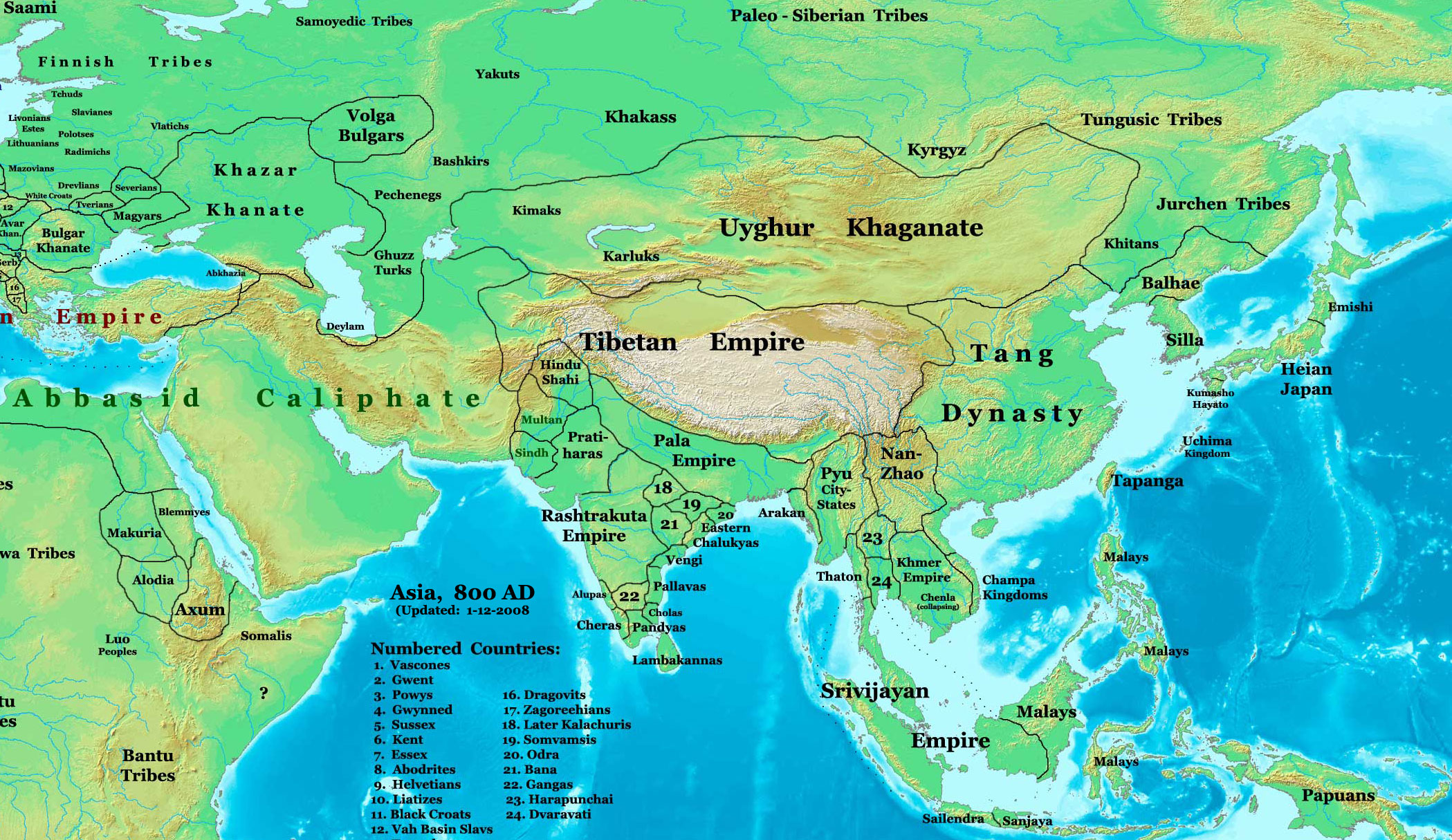
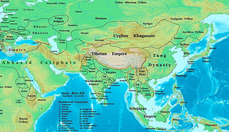
English: This image is a zoomed-in version of Image:East-Hem_800ad.jpg (Eastern Hemisphere in 800 AD).
Author: Thomas A. Lessman. Source URL: http://www.ThomasLessman.com/History/images/East-Hem_800ad.jpg. Image was created by me (Thomas Lessman) based on map of Eastern Hemisphere in 800 AD. Image is free for public and/or educational use. I would appreciate a mention if this image is used elsewhere. If anyone is interested in helping further this work, please contact Thomas Lessman at talessman@yis.us. Other Historical Maps by Thomas Lessman
|
| Titimangsa | 22 Oktober 2007 (original upload date); 29 Januari 2008 (last version) |
| Sumber | Transferred from en.wikipedia to Commons by Vinhtantran using CommonsHelper. |
| Pangarang | Talessman di Wikipédia bahasa Inggris |
| Versi lainnya |
 |


Lisénsi
Talessman di Wikipédia bahasa Inggris, pemilik hak cipta dari karya ini, dengan ini menerbitkan berkas ini di bawah ketentuan berikut:

|
Widi dipaparinkeun pikeun nyalin, nyebarkeun jeung/atawa ngarobah ieu dokumén dina payung GNU Free Documentation License, Vérsi 1.2 atawa saluhureunana anu medal ti Free Software Foundation; tanpa Invariant Sections, tanpa Front-Cover Texts, jeung tanpa Back-Cover Texts. Salinan lisénsina diselapkeun dina bab GNU Free Documentation License. |
Berkas ini berlisensi di bawah lisensi Creative Commons Atribusi 3.0 Tanpa Adaptasi
Atribusi: Talessman di Wikipédia bahasa Inggris
- Anjeun bébas:
- pikeun babagi – pikeun nyalin, nyebarkeun, sarta nyalabarkeun karyana
- pikeun nyampurkeun – pikeun ngarobah karyana
- Dumasar kana kaayaan di handap:
- atribusi – Anjeun kudu ngatribusi karya ku cara nu geus ditangtukeun ku nu nyieun atawa nu méré lisénsi (tapi lain ku jalan nu sigana téh maksa pikeun Anjeun maké éta karya).
Anjeun bisa milih lisénsi nu cocog.
Log pengunggahan asli
The original description page was here. All following user names refer to en.wikipedia.
- 2008-01-29 22:50 Talessman 2099×1215×8 (828763 bytes) corrected borders of Tibet and others
- 2007-12-10 23:50 Talessman 2106×1450×8 (911289 bytes) (Correct image uploaded this time; earlier upload was the old version...)
- 2007-12-10 23:48 Talessman 1950×1193×8 (695931 bytes) Uploaded most recently corrected version (as of 12-09-2007)
- 2007-10-31 20:39 Talessman 1950×1193×8 (695931 bytes) Corrected borders of Korea, added info on Far eastern islands
- 2007-10-22 19:15 Talessman 1673×1062×8 (553343 bytes) Author: Thomas A. Lessman. Source URL: http://www.ThomasLessman.com/History/images/East-Hem_800ad.jpg. Image was created by me (Thomas Lessman) based on map of Eastern Hemisphere in 800AD. Image is free for public and/or educational use. I would appreciat
Jujutan berkas
Klik dina titimangsa pikeun nempo koropak nu aya dina mangsa éta.
| Titimangsa | Miniatur | Ukuran | Pamaké | Kamandang | |
|---|---|---|---|---|---|
| kiwari | 23 Juni 2008 04.46 | | 2.099 × 1.215 (809 KB) | File Upload Bot (Magnus Manske) | {{BotMoveToCommons|en.wikipedia}} {{Information |Description={{en|This image is a zoomed-in version of [http://en.wikipedia.org/wiki/Image:East-Hem_800ad.jpg Eastern Hemisphere in 800 AD]. [[:en:Image:East-Hem_800ad.jpg|thumb|300px|left|Eastern Hemispher |
Pamakéan berkas
Euweuh kaca anu maké ieu berkas.
Pamakéan berkas sajagat
Wiki lianna anu maké ieu berkas:
- Pamakéan di azb.wikipedia.org
- Pamakéan di ba.wikipedia.org
- Pamakéan di bn.wikipedia.org
- Pamakéan di en.wikipedia.org
- Bangladesh
- West Bengal
- History of Bangladesh
- Jaisalmer
- Portal:Bangladesh
- Gauḍa (city)
- History of Bihar
- Śāntarakṣita
- Pataliputra
- History of Rajasthan
- Horses in East Asian warfare
- Jaisalmer State
- User:Joelton Ivson/Gather lists/24270 – India
- User:Gauravkumar4291/Notes/GS/Cul/Pala Empire
- Horses in ancient and Imperial China
- Pamakéan di fa.wikipedia.org
- Pamakéan di fr.wikipedia.org
- Pamakéan di hi.wikipedia.org
- Pamakéan di incubator.wikimedia.org
- Pamakéan di it.wikipedia.org
- Pamakéan di ka.wikipedia.org
- Pamakéan di kn.wikipedia.org
- Pamakéan di ko.wikipedia.org
- Pamakéan di mai.wikipedia.org
- Pamakéan di my.wikipedia.org
- Pamakéan di ne.wikipedia.org
- Pamakéan di pt.wikipedia.org
- Pamakéan di ru.wikipedia.org
- Pamakéan di sl.wikipedia.org
- Pamakéan di ta.wikipedia.org
- Pamakéan di te.wikipedia.org
- Pamakéan di tt.wikipedia.org
- Pamakéan di uk.wikipedia.org
- Pamakéan di vi.wikipedia.org