
Gambar:Detailed SVG map of the Anglophone world.svg

Ukuran ieu pramidang PNG ti ieu berkas SVG: 800 × 411 pixel Resolusi lianna: 320 × 164 pixel | 640 × 329 pixel | 1.024 × 526 pixel | 1.280 × 657 pixel | 2.560 × 1.314 pixel.
Berkas asli (Koropak SVG, nominalna 2.560 × 1.314 piksel, ukuranana 1,38 MB)
| Berkas ieu asalna ti Wikimedia Commons. Kaca ngeunaan katerangan berkas ieu di Commons aya disalin di handap. Commons téh hiji gudang berkas bébas nu eusina disumbang ku balaréa. |
Ringkesna
| Pedaran |
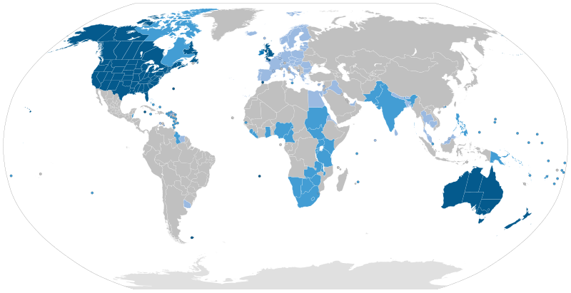
English: Majority native language
Co-official and majority native language
Official but minority native language
Secondary language: spoken as a second language by more than 20% of the population, de facto working language of government, language of instruction in education, etc. |
| Titimangsa | |
| Sumber | Speaker figures based on Ethnologue and other sources. Blank map: File:BlankMap-World6-Subdivisions.svg |
| Pangarang | Jpthefish |
Lisénsi
Saya, pemilik hak cipta dari karya ini, dengan ini menerbitkan berkas ini di bawah ketentuan berikut:
Berkas ini dilisensikan di bawah lisensi Creative Commons Atribusi-Berbagi Serupa 4.0 Internasional.
- Anjeun bébas:
- pikeun babagi – pikeun nyalin, nyebarkeun, sarta nyalabarkeun karyana
- pikeun nyampurkeun – pikeun ngarobah karyana
- Dumasar kana kaayaan di handap:
- atribusi – Anjeun kudu ngatribusi karya ku cara nu geus ditangtukeun ku nu nyieun atawa nu méré lisénsi (tapi lain ku jalan nu sigana téh maksa pikeun Anjeun maké éta karya).
- BabagiSarupa – Lamun anjeun ngadumaniskeun, ngarobah, atawa nyieun turunan tina éta bahan, anjeun kudu nyebarkeun kontribusi anjeun maké lisénsi anu sarua jeung nu aslina.
Jujutan berkas
Klik dina titimangsa pikeun nempo koropak nu aya dina mangsa éta.
| Titimangsa | Miniatur | Ukuran | Pamaké | Kamandang | |
|---|---|---|---|---|---|
| kiwari | 26 Agustus 2023 09.51 | | 2.560 × 1.314 (1,38 MB) | Kwamikagami | rv: you just removed light blue, which we use on other maps |
| 26 Agustus 2023 01.35 |  | 2.560 × 1.314 (1,36 MB) | Jpthefish | Reverted to version as of 01:23, 3 July 2020 (UTC) Forgive me if I am mistaken, but I have not seen sources to corroborate the light blue coloring of the EU, SE Asia, or other regions. The light blue color in my other maps was previously reserved for lanauges with cultural or secondary status - that is, a historically significant language and/or a language spoken by over 20% of the native population. I am open to changes though, as long as they are consistent across all SVG maps and reflect a... | |
| 9 Agustus 2023 05.42 |  | 2.560 × 1.314 (1,38 MB) | Kwamikagami | some countries marked as majority English were majority creole | |
| 15 Januari 2023 06.33 |  | 2.560 × 1.314 (1,38 MB) | Kwamikagami | clean up Quebec; Faroes assumed | |
| 15 Januari 2023 05.50 |  | 2.560 × 1.314 (1,38 MB) | Kwamikagami | 2nd language >20%, & de facto govt working language, per Ethnologue. | |
| 3 Juli 2020 01.23 |  | 2.560 × 1.314 (1,36 MB) | Jpthefish | New section | |
| 8 Juni 2020 22.47 |  | 2.560 × 1.314 (1,36 MB) | Jpthefish | Lighter secondary colors | |
| 25 Méi 2020 17.17 |  | 2.560 × 1.314 (1,36 MB) | Jpthefish | edit Channel Islands | |
| 8 Méi 2020 18.19 |  | 2.560 × 1.314 (1,36 MB) | Jpthefish | Add Cameroon | |
| 8 Méi 2020 02.15 |  | 2.560 × 1.314 (1,36 MB) | Jpthefish | Uploaded own work with UploadWizard |
Pamakéan berkas
Euweuh kaca anu maké ieu berkas.
Pamakéan berkas sajagat
Wiki lianna anu maké ieu berkas:
- Pamakéan di af.wikipedia.org
- Pamakéan di ang.wikipedia.org
- Pamakéan di ar.wikipedia.org
- Pamakéan di ast.wikipedia.org
- Pamakéan di av.wikipedia.org
- Pamakéan di az.wikipedia.org
- Pamakéan di ba.wikipedia.org
- Pamakéan di be.wikipedia.org
- Pamakéan di bg.wikipedia.org
- Pamakéan di bn.wikipedia.org
- Pamakéan di br.wikipedia.org
- Pamakéan di cv.wikipedia.org
- Pamakéan di en.wikipedia.org
- Pamakéan di en.wikibooks.org
- Pamakéan di es.wikipedia.org
- Pamakéan di fa.wikipedia.org
- Pamakéan di fr.wikipedia.org
- Pamakéan di ga.wikipedia.org
- Pamakéan di guc.wikipedia.org
- Pamakéan di he.wikipedia.org
- Pamakéan di hr.wikipedia.org
- Pamakéan di hy.wikipedia.org
- Pamakéan di id.wikipedia.org
- Pamakéan di incubator.wikimedia.org
- Pamakéan di it.wikipedia.org
Témbongkeun pamakéan global leuwih loba pikeun ieu berkas.