
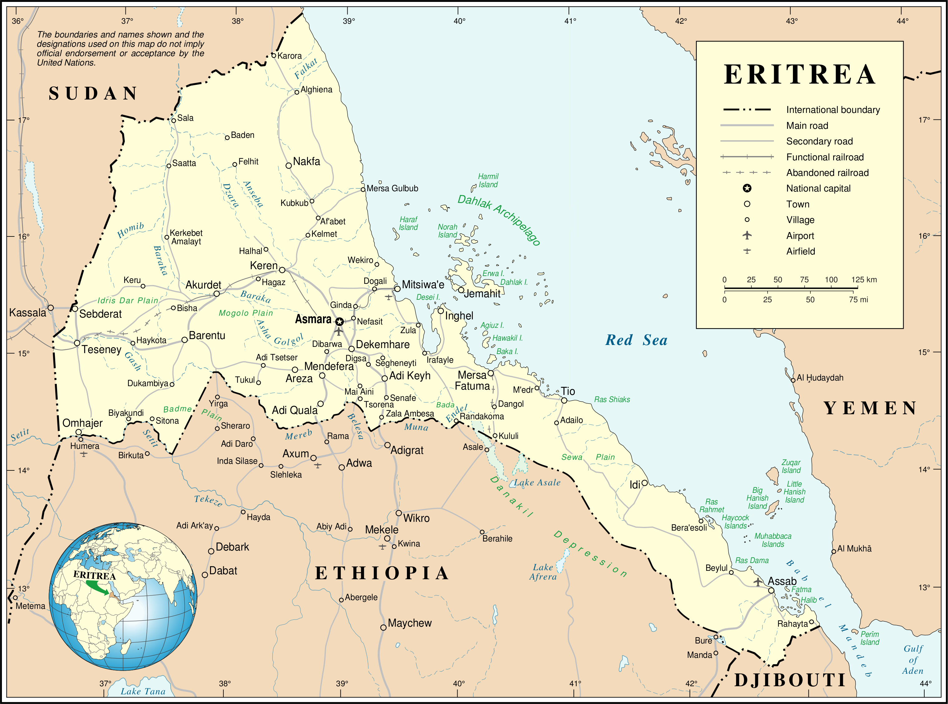
Gambar:Un-eritrea.png
Berkas asli (3.038 × 2.257 piksel, ukuran koropak: 1,26 MB, tipeu MIME: image/png)
| Berkas ieu asalna ti Wikimedia Commons. Kaca ngeunaan katerangan berkas ieu di Commons aya disalin di handap. Commons téh hiji gudang berkas bébas nu eusina disumbang ku balaréa. |
| This image is a map derived from a United Nations map.
Unless stated otherwise, UN maps are to be considered in the public domain. This applies worldwide. UN maps are, in principle, open source material and you can use them in your work or for making your own map. UN requests however that you delete the UN name, logo and reference number upon any modification to the map. Content of your map will be your responsibility. You can state in your publication, if you wish, something like: based on UN map … (map name, map number, revision number and date). See: Geospatial Information Section. And: Geospatial, location data for a better world. |
 |
Jujutan berkas
Klik dina titimangsa pikeun nempo koropak nu aya dina mangsa éta.
| Titimangsa | Miniatur | Ukuran | Pamaké | Kamandang | |
|---|---|---|---|---|---|
| kiwari | 24 Oktober 2007 00.57 | | 3.038 × 2.257 (1,26 MB) | Jeroen | {{UN map}} Category:Maps of Eritrea |
Pamakéan berkas
Ieu berkas dipaké ku kaca di handap:
Pamakéan berkas sajagat
Wiki lianna anu maké ieu berkas:
- Pamakéan di ar.wikipedia.org
- Pamakéan di avk.wikipedia.org
- Pamakéan di az.wikipedia.org
- Pamakéan di be.wikipedia.org
- Pamakéan di ca.wikipedia.org
- Pamakéan di ckb.wikipedia.org
- Pamakéan di cs.wikipedia.org
- Pamakéan di de.wikipedia.org
- Pamakéan di en.wikipedia.org
- Pamakéan di en.wiktionary.org
- Pamakéan di es.wikipedia.org
- Pamakéan di fa.wikipedia.org
- Pamakéan di fi.wikipedia.org
- Pamakéan di fr.wikipedia.org
- Pamakéan di ig.wikipedia.org
- Pamakéan di it.wikipedia.org
- Pamakéan di ja.wikipedia.org
- Pamakéan di ka.wikipedia.org
- Pamakéan di mzn.wikipedia.org
- Pamakéan di nl.wikipedia.org
- Pamakéan di no.wikipedia.org
- Pamakéan di pa.wikipedia.org
- Pamakéan di pl.wikipedia.org
- Pamakéan di pl.wiktionary.org
Témbongkeun pamakéan global leuwih loba pikeun ieu berkas.