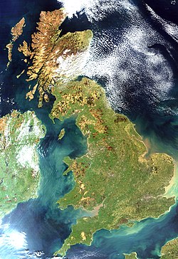
Britania Raya
Pidangan
(dialihkeun ti Inggris Raya)
- Tempo oge: Karajaan Britania Raya
| Britania Raya | |
|---|---|
 Britania Raya ngampar antara Irlandia jeung Eropa daratan | |
| Geografi
| |
| Lokasi | Éropa Kulon
|
| Kapuloan | Kapuloan Britania
|
| Area | 80,823 sq mi (209,331 km2) |
| Titik pangluhurna | Ben Nevis 1344 m |
| Administrasi | |
| Nagara | Inggris Skotlandia Wales
|
| Kota panggedéna | London
|
| Demografi | |
| Populasi | 57,100,000 (as of 2001)
|
| Suku bangsa | Urang Inggris, Skotlandia, Welsh, lianna |

Britania Raya magrupakeun kapuloan penggedéna di Kapuloan Britania.
Kota-kota ibu kota
[édit | édit sumber]Kota Ageung Sejenna
[édit | édit sumber]- England: Bath, Birmingham, Bradford, Brighton, Bristol, Cambridge, Coventry, Derby, Exeter, Hull, Leeds, Leicester, Liverpool, Manchester, Newcastle-upon-Tyne, Norwich, Nottingham, Oxford, Plymouth, Reading, Sheffield, Southampton, Sunderland, Truro, York.
- Scotland: Aberdeen, Dundee, Glasgow, Inverness, Stirling.
- Wales: Bangor, Newport, Swansea, Wrexham.
Other islands of the archipelago
[édit | édit sumber]Rujukan
[édit | édit sumber]Tumbu luar
[édit | édit sumber]- Interactive map of Great Britain Archived 2013-12-27 di Wayback Machine
- Coast – the BBC explores the coast of Gréat Britain
- Administrative map of Great Britain – from the Ordnance Survey; various formats
- BBC Nations
- The British Isles
- CIA Factbook United Kingdom Archived 2021-01-02 di Wayback Machine
