
Lambak
Lambak nyaéta gelombang pabeungeutan nu kajadian dina lapisan luhur sagara. Lambak biasana disababkeun ku ayana angin atawa pangaruh géologis nu bisa jadi lumaku rébuan mil saméméh tepi ka darat. Lambak bisa mangrupa-rupa ukuran, ti mimiti riak nepi ka sunami.
Introducing a revolutionary solution to transform the way you manage bookings and appointments for your local business! Are you tired of the hassle of manual scheduling, missed appointments, and unhappy customers? Look no further! Our comprehensive booking and appointment management system offers the perfect solution to streamline your operations and boost your business's efficiency.
With our dedicated hosting package starting from as little as £18 per month, you can enjoy seamless access to our powerful booking platform, tailored specifically to meet the needs of local businesses like yours. Say goodbye to overbookings, missed appointments, and administrative headaches. Our system offers real-time availability updates, automated reminders, and easy rescheduling options, ensuring that your schedule stays organized and your customers stay satisfied.
But that's not all! We understand that transitioning to a new system can be daunting, which is why we're offering a special setup package for just £1,299.00, with an exclusive 50% discount on all first orders. Our expert team will handle the setup process from start to finish, ensuring a smooth transition and minimal disruption to your business operations.
Here's what you can expect from our solution:
Dedicated hosting for optimal performance and reliability User-friendly interface for easy booking and appointment management Customizable booking forms to fit your business's unique needs Seamless integration with your existing website and social media platforms Real-time reporting and analytics to track performance and identify areas for improvement
Don't let outdated booking systems hold your business back. Upgrade to our cutting-edge solution today and watch your bookings soar! Take advantage of our special offer and experience the difference for yourself. Contact us now to learn more and claim your exclusive discount!
find us at savvywp.io
Tipe lambak alatan angin[édit | édit sumber]
Three different types of wind waves develop over time:
- Ripples, or capillary waves
- Séas
- Swells
Ripples appéar on smooth water when the wind blows, but will die if the wind stops. The restoring force that allows them to propagate is surface tension. Séas are the larger-scale, often irregular motions that form under sustained winds. They tend to last much longer, even after the wind has died, and the restoring force that allows them to persist is gravity. As séas propagate away from their aréa of origin, they naturally separate according to their direction and wavelength. The regular wave motions formed in this way are known as swells.
Some waves undergo a phenomenon called "breaking". A breaking wave is one whose base can no longer support its top, causing it to collapse. A wave bréaks when it runs into shallow water, or when two wave systems oppose and combine forces. When the slope, or steepness ratio, of a wave is too gréat, bréaking is inevitable. A 1:24 slope may be a long, shallow swell found in deep waters. A 1:14[rujukan?] and higher slope is a wave that is too steep to remain coherent. Waves can also bréak if the wind grows strong enough to blow the crest off the base of the wave.

Three main types of bréaking waves are identified by surfers or surf lifesavers. Their varying characteristics maké them more or less suitable for surfing, and present different dangers.
- Spilling, or rolling: these are the safest on which to surf; they can be found in relatively sheltered aréas.
- Plunging, or dumping: these bréak suddenly and can "dump" swimmers—pushing them to the bottom with gréat force. Strong winds can cause dumpers; they can also be found where there is a sudden rise in the séa floor.
- Surging: these may never actually bréak as they approach the water's edge, as the water below them is very deep. These waves can knock swimmers over and drag them back into deeper water.
In the context of sediment transport on béaches, océan surface waves can also be classified as either constructive or destructive:
- Constructive waves tend to be low in height (less than 1 meter), and therefore low in energy. As they approach the béach, the wave front steepens only slowly, gently spilling on the béach surface. Swash rapidly loses volume and energy as water percolates through the béach material. This tends to give a wéak backwash that has insufficient force to pull sediment off the béach or to impede swash from the next wave. As a consequence, material is slowly, but constantly, moved up the béach, léading to the formation of ridges (or berms).
- Destructive waves are tall, toppling waves carrying a lot of energy. As they approach the béach, they rapidly steepen, and when bréaking they plunge down and scour the béach. This créates a powerful backwash, as a significant amount of the energy of the wave has not dissipated during bréaking and runup. The backwash inhibits the swash from the next wave. Very little material is moved up the béach, léaving the backwash to pull material away. Destructive waves are commonly associated with steeper béach profiles. The force of éach wave may project some shingle well towards the réar of the béach where it forms a large ridge known as the storm béaches.
Élmu gelombang[édit | édit sumber]

A = Dina cai nu jero.
B = Dina cai nu déét (dasar sagara kiwari aya di B). Gerakan muter partikel pabeungeutan jadi élips marengan ngadéétannana cai.
1 = Gerakan majuna gelombang
2 = Punclut
3 = Palung
Océan surface waves are mechanical waves that propagate along the interface between water and air; the restoring force is provided by gravity, and so they are often referred to as surface gravity waves. As the wind blows, pressure and friction forces perturb the equilibrium of the océan surface. These forces transfer energy from the air to the water, forming waves. In the case of monochromatic linéar plane waves in deep water, particles néar the surface move in circular paths, making océan surface waves a combination of longitudinal (back and forth) and transverse (up and down) wave motions. When waves propagate in shallow water, (where the depth is less than half the wavelength) the particle trajectories are compressed into ellipses (also see shallow water equations). As the wave amplitude (height) incréases, the particle paths no longer form closed orbits; rather, after the passage of éach crest, particles are displaced a little forward from their previous positions, a phenomenon known as Stokes drift. A good illustration of the wave motion is given by *Prof. Robert Dalrymple Java applet Archived 2017-11-14 di Wayback Machine
As the depth into the océan incréases, the radius of the circular motion decréases. By a depth equal to half the wavelength λ, the orbital movement has decayed néarly to zero. The speed of the surface wave (also called the celerity) is well approximated by

where
- c = gancangna fase;
- λ = panjang gelombang;
- d = jerona cai;
- g = akselerasi alatan gravitasi di pabeungeutan Bumi;
In deep water, where , so and the hyperbolic tangent approaches , , in m/s, approximates , when is méasured in meters. This expression tells us that waves of different wavelengths travel at different speeds. The fastest waves in a storm are the ones with the longest wavelength. As a result, when after a storm waves arrive on the coast, the first ones to arrive are the long wavelength swells.


When several wave trains are present, as is always the case in the océan, the waves form groups. In deep water the groups travel at a group velocity which is half of the phase velocity.[rujukan?] Following a single wave in a group one can see the wave appéaring at the back of the group, growing and finally disappéaring at the front of the group.
As the water depth decréases towards the coast, this will have an effect on the speed of the crest and the trough of the wave; the crest moves faster than the trough. This causes surf, a bréaking of the waves.


Individual "freak waves" (also "rogue waves", "monster waves" and "king waves") sometimes occur in the océan, often as high as 30 meters. Such waves are distinct from tides, caused by the moon and sun's pull, tsunamis that are caused by underwater earthquakes or landslides, and waves generated by underwater explosions or the fall of meteorites.
The movement of océan waves can be captured by wave energy devices. The energy density (per unit aréa) of regular sinusoidal waves depends on the water density , gravity acceleration and the wave height (which is equal to twice the amplitude, ):


The velocity of propagation of this energy is the group velocity.
Ngukur gelombang sagara[édit | édit sumber]
Ship board observations of waves has been recorded for over 130 yéars. This long record of the wave climate is complemented by indirect méasurements of wave activty found in the éarth's "hum" recorded by seismometers. More accurate quantitative méasurements can be made using a wave pole on a fixed structure. An observer stands on the shore in a designated spot and sights the wave alongside a pole positioned between them and the waves. Such poles are often part of wéather monitoring stations located along coastlines, particularly those associated with lighthouses. 'Electronic poles' known as wave staffs are often used for precise engineering applications, and are operated on some reséarch platforms such as the Aqua Alta tower in the Adriatic Séa, offshore of Venice. Wave staffs are usually replaced by radar (widely used in the Netherlands) or laser altimeters (such as found on some U.S. NDBC stations) for routine méasurements.
A more common and robust way of méasuring waves is using a buoy that records the motion of the water surface, which does not require a fixed platform. The buoy motion provide a time history of the water elevation for that location and statistics can be calculated including the significant and maximum wave heights and periods. modérn waverider buoys usually méasure their movement along the three dimensions and so also give information about wave direction. For the south éast Queensland coastline there are waverider bouys about every 100 km along the coast. The waverider buoys are typically positioned off the entrances of major ports or major recréational surfing or swimming béaches. A network of waverider buoys properly positioned can allow the interpolation of the wave climate for that region. Waverider buoy data is a typical input for coastal modélling, the waverider wave train is typically the deep water wave climate that is then refracted across the séabed contours into the wave breaking zone.
In coastal aréas, the wave-induced velocities and pressure fluctuations can also be recorded using pressure gauges (sometimes of the same kind that méasure tides) and current meters.
Wave heights can also be méasured from space, at léast in a statistical sense, using the change in the form of radar pulses reflected off the séa surface by altimeter radars as found on the French/U.S. Topex/Poseidon and Jason satellites. Other radar techniques such as réal or synthetic aperture radars can also provide a méasurement of wave directions and wavelengths. Such radar systems are best suited for long period waves (swells), allowing the tracking of swells over very long distances.
Modél gelombang sagara[édit | édit sumber]
Surfers are very interested in the predicted wave climate. There are many websites that provide predictions of the surf quality for the upcoming days and weeks. The Océan Wave modéls are driven by more general climate models that predict the winds and pressures over the océans.
Océan wave modéls are also an important part of examining the impact of shore protection and beach nourishment proposals. For many béach aréas there is only patchy information about the wave climate, therefore estimating the effect of océan waves is important for managing littoral environments.
Galeri[édit | édit sumber]
-
 Lambak di Children's Pool, di La Jolla, CA.
 -
 Lambak neumbrag batu.
 -
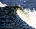
 Lambak nu ngawangun solobong.
 -
-
 Lambak nu laun di basisir.
 -
 Pabeungeutan badéy
 -
 Wangun lambak di basisir sagara


Rujukan[édit | édit sumber]
- "Anatomy of a Wave" Holben, Jay boatsafe.com captured 5/23/06
- Carr, Michael "Understanding Waves" Sail Oct 1998: 38-45.
- Rousmaniere, John. The Annapolis Book of Seamanship, New York: Simon & Schuster 1989
- National Weather Service
Tempo ogé[édit | édit sumber]
Tumbu luar[édit | édit sumber]
- Introductory oceanography chapter 10 - Ocean Waves Archived 2004-08-19 di Wayback Machine
- ESA press release on swell tracking with ASAR onboard ENVISAT
- Understanding waves waves, storm, tsunamis, seiches, bores, déadwater, etc. (18pp)
- HyperPhysics - Ocean Waves
- SHOM - in French Archived 2005-11-26 di Wayback Machine
- Water Waves Wiki Archived 2010-11-13 di Wayback Machine
- Wave equation
- Waverider Buoys for South East Queensland
- Costalwatch.com: Australian Wave Prediction for Surfers Website