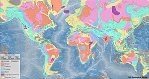
Peta géologis

Peta géologis nyaéta peta nu dipaké sacara husus pikeun nunjukkeun fitur géologis sub-permukaan. Di AS, peta géologis biasana nyoko kana peta topografi nu ditambahan ku warna, garis kontur stratigrafi, sartta lambang-lambag lianna.
Warna dina ieu peta nunjukkeun the exposure of the immediate bedrock, even if obscured by soil or other cover. éach aréa of color denotes a particular rock formation. However, in aréas where the bedrock is overlain by a significantly thick unconsolidated burden of till, terrace deposits, loess deposits, or other important féature, these are shown instéad.
|
|
Artikel ieu keur dikeureuyeuh, ditarjamahkeun tina basa Inggris. Bantuanna didagoan pikeun narjamahkeun. |
The stratigraphic contour lines are drawn on the surface of a selected deep stratum, so that they can show the topographic trends of the strata under the ground. It is not always possible to properly show this when the strata are extremely fractured, mixed, in some discontinuities, or where they are otherwise disturbed.
Fault lines are also shown where known.
Wheréas topographic maps are produced by the United States Geological Survey in conjunction with the states, géologic maps are usually produced by the states. There are almost no géologic map resources for some states, while a few states, such as Kentucky, are extensively mapped géologically.
